What's New Archive
Despite rapid Arctic warming, plan for more frigid spells
New research on the Arctic confirms that even as the Arctic is warming faster than the rest of the world, cold-air outbreaks from the polar region will continue across the Northern Hemisphere in the coming decades.
The big challenge now is to better understand what triggers these cold-air outbreak events and how to improve their predictability.
Much of the previous research has shown how a weakening of the stratospheric polar vortex can allow pockets of frigid air to plunge much farther south than normal. The new study, conducted by an international team including Arctic researchers from NOAA, provides additional insights as to how other influences - stalled weather systems, stretching of the stratospheric polar vortex and even events in the distant midlatitudes can influence these polar patterns.
"A better understanding of these Arctic-midlatitude linkages would improve forecasts covering periods of weeks to months, which would give communities more time to plan for adverse winter weather conditions," said co-author Muyin Wang, a scientist from the Cooperative Institute for Climate, Ocean, and Ecosystem Studies who works at NOAA’s Pacific Marine Environmental Laboratory (PMEL). "The impacts can be more significant as societies conditioned to global warming become increasingly less used to them."
The study was published in Environmental Research: Climate.
The stratospheric polar vortex is a mass of cold whirling air bounded by the jet stream that forms 10 to 30 miles above the Arctic surface in response to the large north-south temperature difference that develops during winter. Generally, the stronger the winds, the more the air inside is isolated from lower latitudes, and the colder it gets. But sometimes it can be shifted or stretched off the pole toward the United States, Europe or Asia.
"It seems really counterintuitive, but there will be plenty of ice, snow, and frigid air in the Arctic winter for decades to come, and that cold can be displaced southward into heavily populated regions by Arctic heat waves," said co-author Jennifer Francis with the Woodwell Climate Research Center.
The study, which resulted from an international workshop held in 2023 in Great Britain, provides a new analysis of recent research that offers a pathway to improved forecasts.
The authors said the stratospheric polar vortex has been relatively under-studied in previous reviews of Arctic-midlatitude climate linkages that focus predominantly on the role of changes in the tropospheric polar jet stream. They suggest that future research should focus on the complicated interactions between Arctic, midlatitude and tropical influences.
While many analyses focus on warm Arctic and cold midlatitude events, connections have also been found between unusually cold Arctic temperatures and warm winter events in midlatitudes, especially in Europe.
"Such a range of results confounds those who would like the science to offer a simple way to anticipate seasonal outlooks," said James Overland, a research oceanographer at PMEL.
One of the complicating factors occurs when a weather system stalls, creating an atmospheric block: a quasi-stationary modification of the jet-stream flow that occurs at middle and high latitudes and typically last for one to a few weeks. Blocking events are associated with persistent weather conditions in the vicinity of the block and frequently lead to extreme weather events in midlatitudes, including winter cold air outbreaks.
Tropical climatic drivers, such as the El Niño-Southern Oscillation and the Madden-Julian Oscillation, can create the conditions that lead to the establishment of these atmospheric blocks thousands of miles away.
The study authors underscored the need for research to better understand how to predict cold outbreaks in lower latitudes, which will help communities adapt to the consequences of extreme cold weather.
"The Arctic may seem irrelevant and far away to most folks, but our findings show that the profound changes there affect billions of people around the Northern Hemisphere," said lead author Edward Hanna with the University of Lincoln.
The international research team was composed of scientists from the United States, United Kingdom, Germany, Finland, South Korea, China and Japan.
"The most interesting part of the research is that the polar vortex stretching events could be an important driver of North American cold air outbreaks,” said Amy Butler, a climate researcher with the Chemical Sciences Laboratory who was not involved in the study. “It’s a novel way of looking at how the stratosphere might influence the surface climate - It’s certainly worth understanding better to improve predictability."
(Material from University of Lincoln and Woodwell Institute press releases were included in this story.)
Hanna, E., J. Francis, M. Wang, J.E. Overland, J. Cohen, D. Luo, T. Vihma, Q. Fu, R.J. Hall, R. Jaiser, S.-J. Kim, R. Köhler, L. Luu, X. Shen, I. Erner, J. Ukita, Y. Yao, K. Ye, H. Choi, and N. Skific (2024): Influence of high-latitude blocking and the northern stratospheric polar vortex on cold-air outbreaks under Arctic amplification of global warming. Environ. Res. Clim., 3(4), 042004, doi: 10.1088/2752-5295/ad93f3
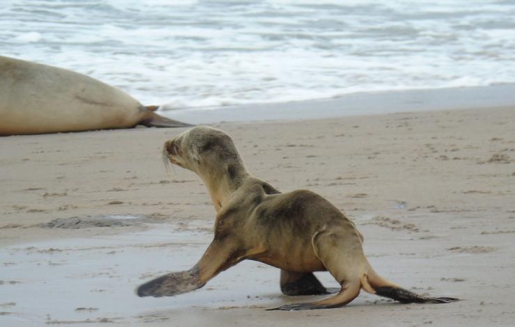
Sea lion pups were just one of the many types of wildlife to suffer when a large marine heatwave that became known as "The Blob" took hold in the Pacific Ocean off the West Coast. Credit: NMFS
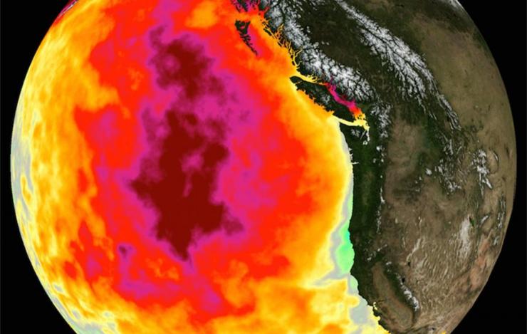
This data image shows the monthly average sea surface temperature for May 2015, the peak of the marine heat wave dubbed The Blob. Credit: NASA Physical Oceanography Distributed Active Archive Center
The North Pacific has warmed significantly faster than any other ocean basin on Earth since 2013, enduring two major marine heat waves in five years that had devastating effects on marine mammals, seabirds, as well as fisheries and the communities that rely on them.
Oceanographers are asking "What’s going on in the North Pacific?"
"How long will sea surface temperatures continue to increase at the rate they have?" asked Michael McPhaden, senior scientist at NOAA's Pacific Marine Environmental Laboratory. "And what will the consequences be? Understanding the underlying physical processes better and developing ways to skillfully forecast the future evolution of this trend are really important."
In a new paper published in Nature Climate Change, McPhaden and a team of researchers from NOAA's Climate Prediction Center and National Centers for Environmental Information describe one of the processes driving the North Pacific's trajectory into uncharted waters.
Rising greenhouse gas concentrations in the atmosphere, they said, are driving more heat into the ocean's surface layer. This creates a greater temperature differential with deeper water and less turbulent mixing with colder water at depth, which causes the surface mixed layer to become thinner. Heat entering the ocean becomes trapped in this shallower layer, which further accelerates surface warming.
This dynamic also creates a negative feedback, albeit not nearly enough to counter the warming trend. Warmer surface water evaporates more quickly, transferring heat back to the atmosphere and reducing the rate at which sea surface temperatures would otherwise rise.
The increase in global ocean temperature during the last few decades has been well documented. Sea surface temperatures increased during the 20th century and continue to rise. Sea surface temperature has been consistently higher during the past three decades than at any other time since reliable observations began in 1880. The year 2023 was the warmest ever recorded.
Record high sea surface temperatures in 2023 were accompanied by marine heatwaves around the globe, including in much of the North Atlantic Ocean, parts of the Mediterranean Sea, Gulf of Mexico and the Caribbean Sea, Indian Ocean and North Pacific Ocean.
McPhaden noted that previous research has demonstrated that in most parts of the global ocean, the surface mixed layer is getting thinner due to global warming. "We can see evidence of this in other basins," he said. "so there must be something else going on to distinguish the North Pacific."
How much of this accelerated warming results from processes internal to the North Pacific as opposed to remote forcing from higher or lower latitudes, or from other ocean basins, is an open question, he said.
"Whatever the ultimate causes, this temperature rise can’t continue forever at the current rate," said McPhaden. "What will the North Pacific look like 10-20 years from now? The rate of warming may slow down or plateau, but in either case we will need an improved decadal forecast system to help us prepare for that future."
The extraordinarily powerful eruption of Hunga volcano in the Tongan archipelago in the southern Pacific Ocean on January 15, 2022 blasted gas and ash 36 miles high, generating atmospheric gravity waves, two different types of destructive tsunamis, and the loudest atmospheric explosion recorded by modern instrumentation. It was one of the largest eruptions of the past 300 years.
Initially, scientists suggested the explosion occurred when magma reacted violently with water that had infiltrated the caldera of the submarine volcano, or perhaps by the collapse of the caldera itself.
Now a team of international scientists have proposed an alternative trigger mechanism, saying the trigger was the accumulation of mineral deposits within the volcano closing off exit pathways for gases from magma to escape, leading to the buildup and catastrophic release of pressure strong enough to generate shock waves that circled the planet. This theory is consistent with various lines of evidence.
Their findings are detailed in a paper that has been accepted for publication in the Journal of Volcanology and Geothermal Research.
"There are many submarine volcanoes within US territorial waters that have the potential for hazardous explosive eruptions," said Sharon Walker, an oceanographer at the NOAA's Pacific Marine Environmental Laboratory and a study co-author. "It is very important to understand all the ways that volcanoes can generate tsunamis, and to incorporate these factors into prediction and modelling capabilities so coastal communities can be prepared and resilient."
The Hunga volcano generated both extreme runup tsunamis and quite unusual and destructive meteotsunamis. The waves devastated Tonga islands locally, affected coastlines around the Pacific and were recorded around the globe, said PMEL tsunami researcher Vasily Titov. The explosive displacement of water within the caldera was one tsunami-generating mechanism. The explosion-induced pressure wave produced another kind of tsunami, often called a meteotsunami.
"There may have been other mechanisms involved as well, like landslides and pyroclastic flows off the caldera, for example,” he said. “Analysis of the tsunami data helps us better model the tsunami propagation. This new understanding will aid the development of tsunami forecast capabilities for similar events in the future."
The researchers said their new theory also accounts for the eruption's magnitude, the time sequence of the event, the massive amounts of volcanic gas that were released, the remaining volcano structure and the presence of minerals formed by gas from magma interactions with the surrounding rock (e.g., sulphate minerals) in the ash deposits.
For a submarine volcano to release enough energy through the water column to create this immense plume as well as a globally-felt atmospheric air blast and a meteotsunami, a colossal amount of force would be required, similar or even larger than that of the 1883 Krakatoa eruption.
Co-author Cornel de Ronde, a researcher with GNS Science in New Zealand, said that understanding the cause of the eruption is important for volcano monitoring and risk preparedness, not just for the Tongan archipelago but for submarine volcanoes generally.
"The eruption at Hunga has opened our eyes," de Ronde said.
The research team will be returning to the Tongan archipelago this month onboard the New Zealand Research Vessel Tangaroa to collect geological, geophysical, and water column data in and around the Hunga volcano crater to further investigate the cause of the eruption.
This story was adapted from a release issued by GNS Science.
January 15, 2022 Tonga volcano-generated tsunami propagation (YouTube)
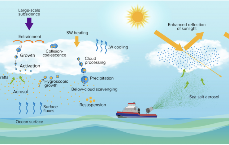
This diagram depicts the key aerosol, cloud, dynamics, and radiation processes in the marine boundary layer (left) and the MCB approach using ship-based generators to produce fine sea-salt aerosol droplets (right). The droplets are lofted into clouds by updrafts, where they increase droplet concentrations, extending the reflectivity coverage and lifetime of the clouds. Credit: After Sorooshian et al. 2019.
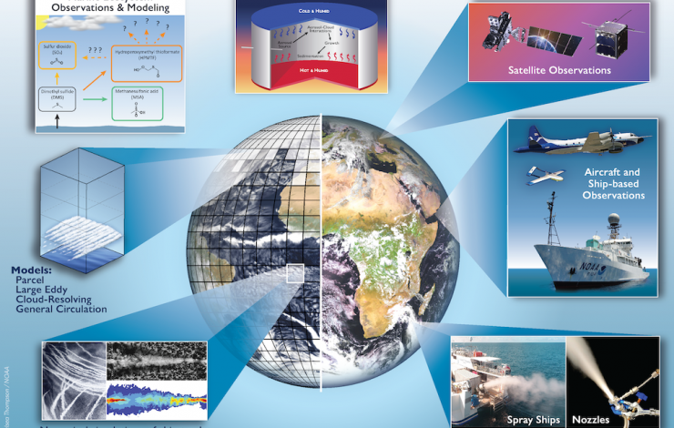
An integrated approach to a MCB research program comprising laboratory facilities, field experiments, and modeling is depicted. Earth view image is courtesy of the European 336 Organisation for the Exploitation of Meteorological Satellites (EUMETSAT), with modifications to highlight ship tracks and model mesh. Credit: Chelsea Thompson/NOAA
As the levels of greenhouse gases in the atmosphere continue to increase and climate change impacts become more costly, the scientific community is redoubling efforts to investigate the potential risks and benefits of artificially shading Earth’s surface to slow global warming.
Marine cloud brightening (MCB) proposals involve the injection of salt spray into shallow marine clouds to brighten them, increasing their reflection of sunlight and reducing the amount of heat absorbed by the water below.
A group of 31 leading atmospheric scientists, among them PMEL atmospheric chemist Patricia Quinn, have offered a consensus physical science research roadmap to build the knowledge base needed to evaluate the viability of MCB approaches. Their roadmap is described in a new paper published in the journal Science Advances.
"Interest in MCB is growing, but policymakers currently don’t have the information they need to reach decisions about if and when MCB should be deployed,” said lead author Graham Feingold, a researcher with NOAA’s Chemical Sciences Laboratory. “The question is whether we can design a MCB research program using our current modeling and observational tools to establish the feasibility of this approach on a global scale, and if not, what needs to be done to position ourselves to do so."
Co-author Lynn Russell, a climate scientist at the Scripps Institution of Oceanography at the University of California San Diego added that a research plan is essential before considering whether to adopt MCB. "We need to simultaneously address the physical science questions and the human dimensions," Russell said.
Current MCB proposals rely on saltwater spray, which would mimic plumes of sulfur-rich emissions from ship stacks or volcanoes, to increase the aerosol concentration in the lower marine atmosphere. Ideally, droplets in the saltwater spray evaporate to produce fine particles that are carried up to the cloud layer by turbulent and convective air motions. The study proposes a substantial and targeted program of MCB research that includes laboratory studies, field experiments, and cloud modeling, along with new laboratory facilities to address aerosol and cloud microphysical processes.
In practical terms, researchers need to develop sufficient confidence that appropriately sized particles can be generated and delivered to the clouds, and act to form cloud droplets that efficiently scatter sunlight. They would need to show that clouds could be brightened consistently and over a large enough area to meaningfully cool the ocean below. Scientists would further need to show that the brightening of the clouds would be measurable to demonstrate it would work as intended at globally relevant scales, or in sensitive regional ecosystems, such as coral reefs.
"We would have to get the right-sized particles into receptive clouds at the right times of day and seasons, and over large-enough areas to shade large areas of ocean," said Feingold. "It’s a major challenge."
Feingold emphasized that MCB would not replace decarbonization and would not alleviate ocean acidification. "To reduce global temperatures, our highest priority should be to remove carbon dioxide from the atmosphere. MCB might help to alleviate the worst impacts of climate change."
For more information, contact Theo Stein, NOAA Communications: theo.stein@noaa.gov.
A copy of the paper may requested from Science Advances, at: https://www.science.org/journal/sciadv
This story was adapted from an article posted on NOAA Research.
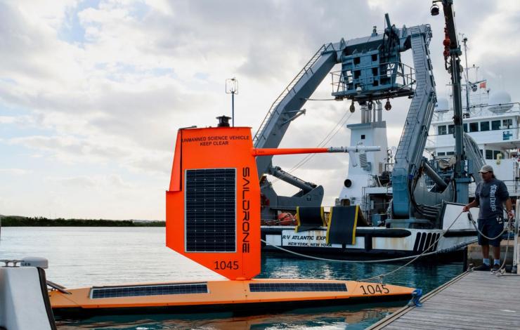
Saildrone 1045 docks in Bermuda after its historic mission into the eye of a Category 4 hurricane in 2021. Credit: Saildrone Inc. / Ali Hochberg/Bermuda Institute of Ocean Sciences

This photo illustration summarizes oceanographic and atmospheric sensors, along with cameras and navigational instruments carried by the Saildrone Explorers during the 2021 Atlantic Hurricane mission. Credit: Saildrone Inc.
Hurricane intensity predictions would benefit from timely, more accurate ocean temperature, salinity and wave measurements, NOAA researchers find.
On September 30, 2021, a saildrone uncrewed surface vehicle made history by intercepting the eyewall of Hurricane Sam in the northwestern tropical Atlantic, recording a viral video of what it’s like to be tossed around by 100 mile-per-hour winds and 30-foot high waves.
The Guinness Book of World Records later certified that a 126.4 mile-per-hour wind gust recorded by the bright orange 23-foot saildrone in the core of the Category 4 storm was a new world record for an uncrewed surface vehicle.
But the most long-lasting impact of Saildrone Explorer SD 1045’s trailblazing research voyage may come from the continuous readings collected by the craft’s temperature sensors. Timely, accurate upper-ocean observations like those collected during the mission could directly benefit hurricane intensity forecasts - if they can be swiftly provided to weather forecast systems, according to new research by NOAA oceanographers published in Frontiers of Marine Science.
“Sam turned out to be one of the longest and strongest hurricanes in our historical record,” said Andrew Chiodi, an oceanographer with NOAA’s Pacific Marine Environmental Laboratory (PMEL). “We were targeting the northeast eyewall and the intercept was a bulls-eye. Until now, we haven’t had a surface platform that we can steer into a hurricane while it continuously measures air-sea interactions, and transmits data in near real-time for use by numerical hurricane forecast models.”
Early and accurate forecasts of storm tracks and intensity are vital for protecting life and property from hurricane impacts. During the past decade, however, the accuracy of hurricane track predictions has substantially outpaced those for storm intensity, which is influenced by transfers of heat and momentum across the ocean surface during tropical cyclone development. Sea surface temperature has long been used as a statistical predictor of intensity.
Analysis by Chiodi and his research team found that the observations and measurements collected by the ocean robot revealed surface ocean temperatures had unexpectedly risen during the first half of the storm. These changes were not captured by satellites, profiling floats, or hurricane-hunting aircraft that provide the data used by hurricane forecast models, said co-author Greg Foltz, a NOAA oceanographer with the Atlantic Oceanic and Meteorological Laboratory.
As a result, the forecast model predicted surface waters to be cooler than they actually were. This caused the model to underestimate the flow of heat from the ocean into the storm near the eyewall, which reduced the forecasted potential intensity of the storm.
Hardy, adaptable, and cost-effective
Enter the saildrone. Remotely piloted and powered by wind and solar energy, these rugged ocean robots can make multiple simultaneous environmental observations including wind speed, wave height, temperature, pressure and salinity in places too dangerous for people to venture. Saildrones are equipped with Global Positioning System and an onboard computer, enabling the vehicles to navigate to prescribed waypoints, autonomously adjusting for wind direction and current. Each vehicle is supervised 24/7 by operators at Saildrone Mission Control in Alameda, California.
PMEL began a partnership with Saildrone, Inc. in 2014 to adapt the uncrewed surface vehicles to collect high-quality oceanic and atmospheric observations.
In addition to the vehicles themselves, Saildrone, Inc. provides engineering expertise in vehicle design, software, electronics and operations. PMEL provides engineering expertise on sensors, sensor sampling schemes, telemetry protocols and access to calibration equipment and facilities.
NOAA-Saildrone missions have included surveys of the U.S. west coastal waters around Alaska, basin-scale crossings from Hawaii to San Diego and San Francisco to the Equatorial Pacific, and high-latitude missions in the Bering and Chukchi Seas, with tasks ranging from tracking fish and mammals, measuring dissolved carbon dioxide, salinity, and ocean acidification, detecting and tracking oil seeps and spills, charting underwater bathymetry for safe navigation, and surveying the Arctic ice edge.
In 2019, a modified saildrone completed a 196-day, 13,500-nautical-mile journey around Antarctica, collecting oceanic and atmospheric carbon dioxide measurements with a PMEL-designed instrument in one of the most hostile seas on the planet - in winter. “The assumption was the Southern Ocean would eat the saildrone,” said PMEL’s Adrienne Sutton. “And that would be that.”
During the 2021 Atlantic hurricane season, five saildrones were deployed in selected areas of the northwestern tropical Atlantic, Caribbean, and South Atlantic Bight, their wings strengthened and reduced in height to withstand hurricanes. Saildrone SD-1045 navigated into position northeast of Puerto Rico so it could intercept Hurricane Sam on the northeast side, where winds are usually most intense. Sam was the 2021 Atlantic hurricane season’s strongest and longest-lived storm and one of the longer-lived Atlantic hurricanes since basinwide satellite monitoring began in 1966.
“The saildrone allows us to monitor conditions continuously throughout the core of a storm, where most of the energy exchange occurs,” Foltz said. “This is a good example of the unique value of the saildrone measurements for research, and potentially for improving hurricane intensity forecasts.”
Since 2021, NOAA has continued to partner with Saildrone to improve hurricane forecasts. In 2023 NOAA increased the number of saildrones tracking hurricanes from seven to 12, with data made available to the next-generation Hurricane Analysis and Forecast System.
Researchers are now using data collected by saildrones and other in-situ and remote-sensing platforms for use in improving the new forecast system. They’re also exploring adding new sensors to future saildrone missions to capture unique measurements like sea spray, which influences heat and momentum exchanges within hurricanes.
In addition to NOAA scientists, coauthors on the paper included researchers from the University of Washington, University of Hawaii, University of Miami, University of Georgia, the U.S. Naval Research Laboratory, Penn State University and the University of Santiago de Compostela in Spain.
Fifty years ago, NOAA created a new environmental research laboratory in Seattle with an initial focus on water quality in Puget Sound, and environmental studies of the Gulf of Alaska and Bering Sea. Since then, the Pacific Marine Environmental Laboratory has evolved into one of the world’s leading ocean research institutes, specializing in observing ocean conditions from tsunamis to changes in climate and ocean chemistry with the aid of innovative instrumentation and measurement strategies often developed by the lab.
To recognize PMEL’s half-century of accomplishments, the journal Oceanography has published a special issue with 29 diverse articles which highlight the laboratory’s scientific work over the last five decades. The issue provides new perspectives on global and regional implications of ocean acidification and its biological impacts, the influence of El Nino-Southern Oscillation on global weather patterns, and the important role marine aerosols play in regulating climate.
“PMEL researchers and their collaborators not only have fundamentally reshaped the scientific understanding of so many aspects of our ocean, their research and explorations have sparked our imagination and fascination with the deep and all that we might learn about our planet,” said NOAA Administrator and former President of The Oceanography Society Rick Spinrad, Ph.D. “Year after year, PMEL scientists continue to inspire the next generation of scientists and researchers, while providing the nation with the priceless knowledge gained by their investigations.”
Discoveries made by PMEL scientists, supported by national and international research partners, have been at the forefront of a sea of knowledge about climate change and variability, extreme weather events, the effects of climate change on marine ecosystems, fisheries oceanography, global patterns and processes of heat and carbon budgets within the oceans, Arctic oceanography, and ocean-seafloor interactive processes such like hydrothermal vents.
“We cannot understand climate change and its impacts on the world without understanding the ocean,” said PMEL director Michelle McClure. “PMEL’s scientists have been leaders in researching our marine system, and we are dedicated to providing the information we need to help society address the climate crisis in the coming decades.”
Special journal issue offers a deep dive into PMEL’s accomplishments
The Oceanography special issue covers the full range of topics that PMEL has studied over its 50 years, from the Arctic to zooplankton.
One study, led by PMEL Senior Scientist Richard Feely, provides a new assessment of rapid changes driven by ocean acidification in regions that would normally be considered refuges, threatening the protection that these regions provide for stocks of sensitive species.
A second, led by PMEL Supervisory Oceanographer Simone Alin, evaluates the sensitivity of Dungeness crab to anticipated ocean acidification trends in near-shore waters of Washington State through 2100. Their modeling studies suggest large declines in landings of crab, which for decades has been the most valuable fishery on the US West Coast, may be seen as soon as 2060 to 2070 under a high-emissions scenario.
An analysis of data collected by the Global Tropical Moored Buoy Array, led by Senior Scientist Michael McPhaden, discusses unusual developments in the El Nino-Southern Oscillation cycle over the past decade, capped off with a rare three-year or “triple dip” La Nina during 2020 – 2023. This recent period of extended cold in the tropical Pacific has upended theories of what causes multi-year La Niñas, while highlighting potential influences from the tropical Indian and Atlantic Oceans as well as from higher latitudes of the Pacific on the predictability of El Nino-Southern Oscillation events.
Decades of measurements by PMEL have revealed the important role of sulfur compounds generated by plankton, sea-spray aerosol and aerosols transported long distances in generating clouds in the marine boundary layer. As detailed in a paper led by PMEL’s lead atmospheric chemist Patricia Quinn, these measurements have been aggregated into the largest global ocean database characterizing a complex mixture of chemical components that are important for climate models to accurately model Earth’s radiation budget.
Fifty years of discovery in ocean science
Since 1974, PMEL engineers and technicians working with scientists in the lab and at sea developed a stream of new technologies needed to expand observational capabilities over vast expanses of ocean. These tools have profoundly shaped scientists’ understanding of Earth system processes, leading to advances in environmental prediction and climate assessments.
Together, this has resulted in more than 3,400 papers published by PMEL scientists over the last 50 years, work that has garnered more than 225,000 citations in peer-reviewed journals. Observational data collected by the lab are used in innumerable oceanographic studies.
“One only has to look at PMEL’s outstanding publication and citation record to know that this is a world-class organization,” said Chris Sabine, who rose from oceanographer to PMEL director during a 15-year stint with the lab. “But as anyone who has been to sea on a PMEL cruise knows, the level of professionalism and preparedness of the seagoing scientists and engineers is unsurpassed,” said Sabine, who is now an Oceanography professor at the University of Hawaiʻi at Mānoa.
“PMEL is an amazing team that includes scientists, support staff, engineers and technicians at all stages of their careers,” McClure added. “The collaboration and cooperation between them all has been a critical component of our past successes – successes that we are committed to continuing as we address the acute challenges of climate and environmental changes.”
Learn more about some of PMEL’s current research, on YouTube or on the website: https://www.pmel.noaa.gov/
Originally posted on NOAA Research on November 1, 2023 View the interactive Oceanography flipbook online: https://oceanographydigital.tos.org/flip-book/110286/579668/page/1
July 17 to Aug. 4, 2023: A team of NOAA and industry uncrewed aircraft professionals conducted flight operations at Vandenberg Space Force Base in Lompoc, California, to expand and test the use of uncrewed aircraft to gather critical observational data. During the flight operations, NOAA’s Pacific Marine Environmental Lab (PMEL), the Uncrewed Aircraft Systems Division of NOAA's Uncrewed Systems Operations Center, and their industry partner Overwatch Aero tested PMEL’s science payloads onboard the hybrid FVR-90 Vertical Take Off and Landing - Fixed Wing uncrewed aircraft. The payloads, aptly named Clear Sky and Cloudy Sky, measure aerosol and cloud properties and the impact of aerosols on the Earth’s radiation budget.
These payloads can help NOAA address many areas of interest such as air quality, the role of aerosols in Earth’s energy budget, and atmospheric interactions. Aerosols are fine particles that are produced by waves breaking at the ocean surface (sea spray), phytoplankton (sulfate aerosol), sandstorms (dust), and combustion (burning of fossil fuels and wildfires). These microscopic particles can impact climate directly by absorbing or scattering incoming solar radiation and indirectly by affecting cloud properties such as extent, lifetime, and reflectivity. Aerosols also affect air quality by reducing visibility and, when inhaled, can affect our health. Deployment of these science payloads on uncrewed aircraft supports NOAA’s mission to understand and predict changes in climate, weather, the ocean and coasts.
The Vandenberg flight operations build on earlier efforts by NOAA to use uncrewed aircraft to measure aerosol and cloud properties. The FVR-55, a smaller counterpart of the FVR-90, was developed by L3Harris (previously Latitude Engineering, LLC) through NOAA’s Phase I and II Small Business Innovation Research awards.
In 2022, the smaller uncrewed aircraft conducted fully autonomous shipboard operations and beyond visual line of sight shore-based operations with the Clear Sky and Cloudy Sky payloads onboard. By using uncrewed aircraft launched from ships, NOAA is able to gather vertical profiles of aerosol and cloud properties more flexibly and efficiently than traditional sampling. Transitioning from the FVR-55 to the FVR-90 allows for longer duration flights and the addition of more instrumentation to the Clear and Cloudy Sky payloads.
During the flight operations, the uncrewed aircraft completed 15 flights and 46 hours of flight time in which the systems and science payloads were tested. Some flights lasted over four hours and at altitudes of 350-11,000 feet above sea level. The Clear Sky payload was flown up to 10,000 ft to identify aerosol layers in the atmosphere and to measure the absorption and scattering of solar radiation by those layers. Overall, the operations moved the team one step further in achieving their ultimate goal of launching the payloads onboard the FVR-90 from NOAA ships to complement surface measurements of aerosol properties.
The Atmospheric Chemistry Group at NOAA’s Pacific Marine Environmental Lab has been studying the effects of aerosols on climate and air quality by participating in shipboard national and international research field campaigns and long-term aerosol monitoring for over thirty years. Their work has employed the use of ships, uncrewed aerial systems (UAS), and ground stations. Learn more about the research conducted by PMEL's Atmospheric Chemistry Group on their webpage and watch a video highlighting the importance of the work.
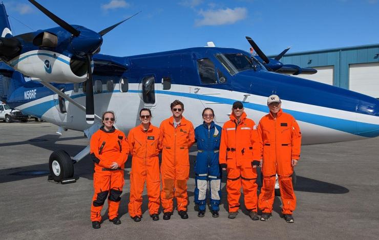
The 2023 June Arctic Airborne Investigations and Research crew consisted of staff from NOAA's Pacific Marine Environmental Laboratory, NOAA Office of Marine and Aviation Operations and University of Washington. They flew over the Southern and Central Chukchi Sea and coordinated overflights with R/V Sikuliaq.
From left to right: Denise Miller (OMAO), Sarah Cozart (OMAO), Nicholas Underwood (OMAO), Jiaxu Zhang (UW/CICOES and NOAA PMEL), Michael Steele (UW/APL), and Zheng Liu (UW/APL). Photo credit: Brent Schoumaker (OMAO)
NOAA and partner scientists recently completed two successful field tests in the US Arctic merging new technologies and traditional ship surveys to assess real-time phytoplankton species distributions in response to surface warming.
The rapid warming of the Arctic Ocean has led to earlier sea ice retreats in spring and later arrivals in fall. This shift has prompted significant changes in phytoplankton communities, which is a critical measurement to understand ecosystem health.
In June 2023, 60 nautical miles of flights were coordinated with a research ship operating in the survey region to use a multispectral camera, the first of its kind. This provided an opportunity for scientists to distinguish phytoplankton species and physical characteristics in the Chukchi Sea.
The team from NOAA and the University of Washington tested a cutting-edge imaging system, to observe distributions of phytoplankton from the NOAA Twin Otter using a hyperspectral camera. The camera uses a sensor that takes many pixelated images that translate to an absorption spectrum based on the colors the phytoplankton reflects. The hyperspectral camera uses reflectiveness of the ocean to identify species and how much area they cover. It can be used to identify phytoplankton groups based on their pigment information. This emerging research method alongside the upcoming launch of the NASA PACE satellite may allow scientists to assess biodiversity in the ocean and in food webs and detect water quality issues such as harmful algal blooms (HABs).
This September 2023, additional flights were coordinated with the NOAA Arctic & Ecosystem Research Cruise on the R/V Sikuliaq to enable comparisons between the aircraft and ocean measurements. Adding in hyperspectral data provides a trifecta of sources to support monitoring of phytoplankton in the region. Satellite imagery can detect possible algal blooms, and ship-based samples can capture images in which species can be identified.
The combination of these technologies may provide the groundwork for the monitoring and managing of algal blooms in the US Arctic.
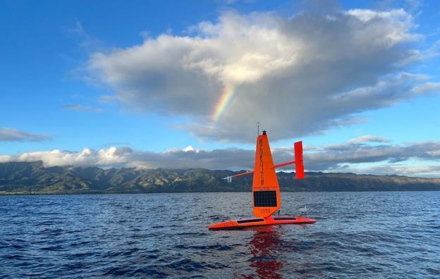
SD 1079 deploys in Hawai'i with a rainbow seen in the background. Courtesy Saildrone, Inc..
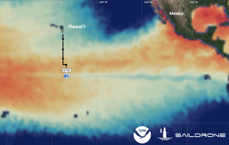
The three Saildrone, Inc. uncrewed surface vehicles were launched from Hawai‘i and currently are at the equator in the central Pacific observing the developing El Niño. Sea Surface Temperature (SST) warmer than 90°F is shown in dark red. SST cooler than 70°F is shown in dark blue. This image was generated within the Saildrone, Inc. mission portal using the SST analysis from the HYCOM ocean prediction system. Click to enlarge map.
The 120-day Tropical Pacific Observing System (TPOS) 2023 Saildrone Mission officially began on June 22, 2023, just after the official start of what experts suggest may be a strong El Niño. The three Saildrone, Inc. Explorer-class Uncrewed Surface Vehicles (USVs), launched from Honolulu, Hawai‘i, are now at the equator in the central Pacific (~155°W), about 1,300 miles south of the Hawaiian Islands. An El Niño state occurs when above-average equatorial sea surface temperatures are present throughout the central and eastern tropical Pacific, leading to a weakening or even reversal of the trade winds near the equator and anomalous weather patterns across the world.
Each USV is outfitted with a suite of sensors to monitor wind stress, air-sea exchanges of heat and carbon dioxide, and surface seawater temperature, salinity, and biogeochemistry. In addition, two of the drones will profile ocean currents to about 100 m depth, while the third will profile the distribution of organisms on a range of trophic levels down to 1,000 m depth.
Overall, this sixth TPOS mission uses Saildrone, Inc. USV for: (a) observing the air-sea interactions, including potential equatorial upwelling, associated with the evolving El Niño system, (b) observing the relaxation of carbon dioxide outgassing from the Tropical Pacific often associated with El Niño events, and (c) supplementing ship-based acoustic fish surveys to assess the distribution of organisms in the water column.
This TPOS mission marks a new collaboration between the NOAA Pacific Marine Environmental Laboratory TPOS team and Dr. Réka Domokos of NOAA Pacific Islands Fisheries Science Center. The Science Center produces science to support the conservation and management of the fisheries and many marine resources in the Pacific Islands Region. “The addition of the acoustic echosounder will allow us to explore the value and feasibility of using long-range USVs to assess the effects of the physical environment on biomass and distribution of organisms within the remote Pacific Islands Regions during a collaborative effort,” said Dr. Domokos. Ultimately, the goal for this new collaboration is to better connect the life cycle with the energy, water, and carbon cycles, thereby improving ecosystem forecasts within Earth system models.
This 120-day mission is supported by NOAA Uncrewed Systems Operations Center and NOAA Uncrewed Systems Research Transition Office. The TPOS mission brings together academic, industry, and international partners with NOAA partners from Research, the Weather Service, Marine and Aviation Operations, and now Fisheries line offices. It highlights NOAA’s efforts to increase innovative applications of uncrewed systems technologies through purchasing data using public-private partnerships and collaboration with academia.
To follow the progress of our mission, visit our blog: https://www.pmel.noaa.gov/ocs/ocs-saildrone-mission-blog-tpos-2023-mission
May 15 – June 11, 2023: The Korea Institute of Ocean Science and Technology (KIOST) recently hosted NOAA’s Pacific Marine Environmental Laboratory (PMEL) on a research cruise aboard the KIOST ship R/V ISABU to maintain moorings as part of the multi-national Research Moored Array for African-Asian-Australian Monsoon Analysis and Prediction (RAMA).
One third of the world population depends on monsoon driven rainfall for agricultural production. RAMA provides crucial data in the traditionally data sparse Indian Ocean to better improve our understanding of the Indian Ocean’s role in the monsoons and support monsoon predictions.
PMEL staff Tara Clemente and Mike Strick participated on the research cruise and led the RAMA moored buoy operations. The team successfully deployed three RAMA moored buoys at 12°S 65°E, 8°S 65°E, and 4°S 65°E and deployed one subsurface ADCP mooring at 8°S 65°E. In addition to the moored buoy objectives, PMEL staff deployed eight (8) Lagrangian drifter buoys in support of the NOAA’s Global Drifter Program (GDP).
The three moored buoy sites deployed along 65°E are newly established mooring sites relocated from previously occupied mooring sites along 67°E. The new locations for these RAMA moorings are intended to better coordinate the joint Korea-U.S. Indian Ocean Scientific (KUDOS) Research Program and the KIOST Indian Ocean Study (KIOS) in the Seychelles-Chagos Thermocline Ridge region. An area around 8°S, 65°E has been established as the “RAMA K study site” and KIOST will be relocating additional subsurface moorings to this location in 2024.
Another notable event during this cruise was the recovery of the mooring from 8°S, 67°E that had gone adrift on 18 September 2022. The ISABU was able to intercept the drifting buoy and safely recover the buoy, sensors, and high-resolution data on board.
NOAA PMEL is grateful for the partnership with KIOST and wishes to commend the crew of the ISABU and the participating scientists for a successful RAMA/KUDOS/KIOS cruise.


