| |
Teacher
Logbook:
Thursday, July 27, 2000
Carol's
Observations
The scientists are working a 12-hour day and longer. The casts and tows
continue around the clock. It takes many people to conduct a tow. The
purpose of the tow is to define the horizontal and vertical distribution
of the plume and its chemical and thermal signature. My job is to record
the data that pinpoints the position of the ship and CTD throughout a
tow. A scientist watches a real-time graph of the CTD's position and calls
out the information to be recorded. I enter this information in the computer's
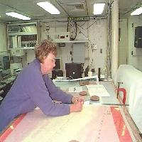
spreadsheet program. Next, I move to the large table to plot the positions
on the huge Cleft segment bathymetric map. I use the longitude and latitude
readings to locate the ship's position. A black triangle is marked on
the map and the time written next to it. During the tow the CTD is far
behind the ship. The CTD is connected to the ship by a multi-strand cable
hundreds of meters long. The actual position of the CTD is recorded on
the map using the computer calculated setback distance. I use a blue triangle
and the time to mark the CTD's position. These positions are marked on
the bathymetric map anytime an altitude is taken or a nisken bottle is
tripped to take a sample of the seawater. At times I am recording data
every two or three minutes.
Today has been an overcast
day with light rain. There is the usual swell with very few white caps.
There is so much going on I don't mind the rain. I keep looking for birds,
but there is only one black-footed albatross gliding above the water.
Join us to see what new adventures that Mary Beth and I have tomorrow.
Carol
Mary Beth's
Observations
Today we are
finishing up at the south Cleft segment. The CTD casts and tows are running
round the clock despite some setbacks with the CTD unit. The science team
works together to ensure the CTD unit is running correctly and recording
accurate data. The scientists have to be their own best resources because
it is very difficult to contact individuals on shore who may be able to
help. They have brought back-up instruments in case of equipment failure
and have brought the tools necessary to repair all the equipment. As I
mentioned earlier on the cruise, there is a workout facility available
to everybody on the ship. Because it is rainy and cold outside again today,
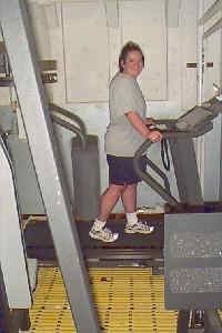
I have chosen this inside location for my focus of the day. The workout
room is located at almost the bottom of the ship, to minimize rocking
and rolling off the machines. Equipment includes a treadmill, two stationary
bicycles, a rowing machine, a weight machine, free weights and a jump
rope. Personally I just stick to the treadmill because I think it would
be pretty hard to jump rope on a moving ship. The weight room is open
24 hours a day because people are working at all hours of the day. Because
of the shift schedule some people may chose to work out at 2:00a.m. or
at 2:00p.m. I work out when I get up in the morning at about 9:30am. It
gets me going for the day and keeps me ready for hiking when I get off
the boat on August 4th in Seattle. Look for more descriptions of the Ronald
H. Brown in tomorrow's update.
On this cruise, the MAPR's
were recovered when we recovered moorings the first couple days of the
cruise. They are scheduled to return to the ocean before we return to
Seattle. Before they can be deployed, the data is downloaded, the batteries
are changed and the titanium housing are cleaned. Stay tuned for pictures
of the MAPRs being deployed back into the ocean!
|
|

Carol plotting the CTD position.

Mary Beth taking a break from CTD work on the treadmill.
|
|

