Feature Publication Archive

A deep-sea octopus explores the brand-new lava flows erupted at Axial Seamount in 2015. At the time, this was probably the youngest seafloor on the planet. Photo Credit: Bill Chadwick, Oregon State University/PMEL, and ROV Jason, Woods Hole Oceanographic Institution
Chadwick, Jr., W.W., B.P. Paduan, D.A. Clague, B.M. Dreyer, S.G. Merle, A.M. Bobbitt, D.W. Caress, B.T. Philip, D.S. Kelley, and S.L. Nooner (2016): Voluminous eruption from a zoned magma body after an increase in supply rate at Axial Seamount. Geophys. Res. Lett., 43 (23), 12,063–12,070, doi:10.1002/2016GL071327.
Nooner, S.L., and W.W. Chadwick, Jr. (2016): Inflation-predictable behavior and co-eruption deformation at Axial Seamount. Science, 354 (6318), 1399–1403, doi:10.1126/science.aah4666.
Wilcock, W.S.D., M. Tolstoy, F. Waldhauser, C. Garcia, Y.J. Tan, D.R. Bohnenstiehl, J. Caplan-Auerback, R.P. Dziak, A.F. Arnulf, and M.E. Mann (2016): The 2015 eruption of Axial Seamount: Seismic constraints on caldera dynamics. Science, 354 (6318), 1395–1399, doi:10.1126/science.aah5563.
Axial Seamount, 300 miles off the coast of Oregon and 0.7 miles beneath the ocean’s surface, is situated along a mid-ocean ridge where two ocean plates are moving apart. It is the most active submarine volcano in the northeast Pacific Ocean, with documented eruptions in 1998, 2011, and most recently, in 2015. Its activity has been monitored for two decades, since the establishment of the NeMO Seafloor Observatory in 1996, and more recently the launch of the National Science Foundation’s Ocean Observatories Initiative Cabled Array, which provides state-of-the-art monitoring capability with... more »

NOAA Ship Oscar Dyson crew retrieve a CTD (Conductivity, Temperature and Depth) in the Eastern Bering Sea during an Ecosystems and Fisheries-Oceanography Coordinated Investigations (EcoFOCI) cruise.
Van Pelt, T.I., J.M. Napp, C.J. Ashjan, H.R. Harvey, M.W. Lomas, M.F. Sigler, and P.J. Stabeno (2016): An introduction and overview of the Bering Sea Project: Volume IV. Deep-Sea Res. II, 134, 3–12, doi:10.1016/j.dsr2.2016.09.002.
“…the National Science Foundation (NSF) and the North Pacific Research Board (NPRB) created a novel partnership in 2007 to support an ecosystem-scale study to examine how a changing climate and changing sea-ice conditions affect the EBS ecosystem, from physics and chemistry to lower trophic level organisms (e.g., plankton) to humans. The “Bering Sea Project” integrated two major research programs, the NSF-funded Bering Ecosystem Study (BEST) and the NPRB-funded Bering Sea Integrated Ecosystem Research Program (BSIERP... more »

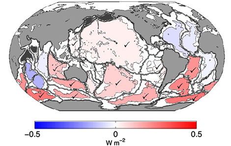
Basin-averaged 1991–2010 warming rates (expressed in W m-2, see colorbar) for the abyssal ocean (4000–6000 m) estimated using data from repeated high-quality, full-depth, coast-to-coast global surveys of ocean water properties. Check marks indicate basins in which warming rates are statistically significantly different from zero
Desbruyères, D.G., S.G. Purkey, E.L. McDonagh, G.C. Johnson, and B.A. King (2016): Deep and abyssal ocean warming from 35 years of repeat hydrography. Geophys. Res. Lett., 43, 10356–10365, doi:10.1002/2016GL070413.
Decadal repeats of high-quality, full-depth, coast-to-coast global surveys of ocean water properties have been revisited since the 1980s. These surveys were completed first under the auspices of the World Ocean Circulation Experiment, then CLIVAR/CO2, and now GO-SHIP. The data from these surveys provide global ocean observations below the 2000-meter sampling limit of core Argo floats. Evaluation of deep warming trends below 2000 m using these highly accurate (±0.002°C) survey data yields an estimate of a net heating rate of 33 ± 20 TW (1 TW = 1,000,000,000,000 Watts) from 1991 to 2010,... more »

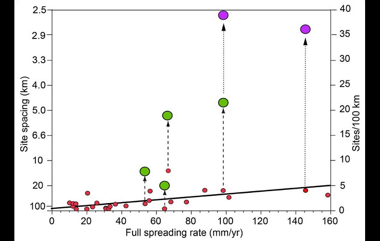
Scatter plot of site spacing (left axis) and site spatial frequency (right axis) vs. ridge spreading rate for 27 ridge sections using data from the InterRidge database (red dots). Green symbols show new survey results from four of these sections; purple symbols show corroborating results from prior intensive camera surveys. Heavy black line is a linear regression between site spacing and spreading rate for the existing database (red dots).
Baker, E.T., J.A. Resing, R.M. Haymon, V. Tunnicliffe, J.W. Lavelle, F. Martinez, V. Ferrini, S.L. Walker, and K. Nakamura (2016): How many vent fields? New estimates of vent field populations on ocean ridges from precise mapping of hydrothermal discharge locations. Earth Planet. Sci. Lett., 449, 186–196, doi:10.1016/j.epsl.2016.05.031.
The heat from submarine volcanoes produces hundreds of hydrothermal hot springs along the mid-ocean ridge crest. These springs promote the exchange of heat and chemicals between the Earth’s crust and the ocean, providing energy to support ecosystems fueled by chemical reactions and creating exploitable deposits of mineral and bio-active resources. A new study by Baker et al. indicates that hot springs are far more common than previously thought, a discovery with crucial implications for diverse hypotheses by chemists, biologists, geologists, and others interested in ocean-seafloor... more »

Quarterly time-series estimates of aragonite saturation state from 15 to 500 meters water depth at CalCOFI Station 80.0 80, in the California Current. Dashed vertical white lines denote the extreme 1997–1999 ENSO period. Solid horizontal white lines represent the decadal average depths of the aragonite saturation horizon before and after the ENSO event.
McClatchie, S., A. R. Thompson, S. R. Alin, S. Siedlecki, W. Watson, and S. J. Bograd (2016), The influence of Pacific Equatorial Water on fish diversity in the southern California Current System,J. Geophys. Res. Oceans, 121, doi:10.1002/2016JC011672.
Changes in large-scale ocean circulation due to climate change appear to be underway throughout the world ocean and stand to significantly affect marine ecosystems and resources. This new study by McClatchie et al. investigated whether changes in the character of coastal waters over the last 30 years have affected the composition of fish communities in the southern California Current ecosystem. The California Undercurrent transports Pacific Equatorial Water into the Southern California Bight from... more »


