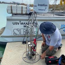
Collecting the very first direct ocean measurements to fill important gaps in understanding the Hunga Tonga-Hunga Ha'apai eruption
Scientist(s):
July – August 2022: PMEL's Sharon Walker joined a team of engineers, multibeam mapping experts, and scientists from around the globe to complete a high-resolution bathymetric and hydrothermal plume survey of the post-eruption caldera at the Hunga Tonga-Hunga Ha’apai (HTHH) volcano. This is the first time a survey that includes direct measurements of the water column up to 300 meters deep has been conducted entirely remotely using an uncrewed surface vessel operated and monitored by engineers and scientists who are located across the globe.


