National Oceanic and
Atmospheric Administration
United States Department of Commerce

Engineering

Annual Spring Survey Encounters Ice in the Bering Sea

April 21 - May 8 -  NOAA PMEL oceanographers and colleagues continue leading an annual effort to collect key data in understanding  the Bering Sea. This important research cruise provides key insights to monitor events such as sea-ice loss and the cold pool in the region and how these are impacting the Arctic ecosystem. This year’s cruise started out a bit different! 

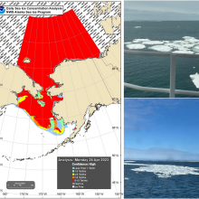
Map with red extent of sea ice covering part of the Bering Sea and the Arctic region. Images on the right show floating sea ice in the water.

Annual Ecosystems & Fisheries-Oceanography Coordinated Investigations (EcoFOCI) Survey in the Bering Sea encounters sea ice (right images) for the first time since 2012. The map (left) shows sea ice extent in the region on April 24, 2023. Photo Credits: Shaun Bell

Pages

Subscribe to RSS - Engineering