SOCAT
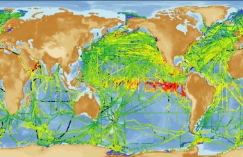
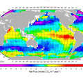
The Surface Ocean CO2 ATlas (SOCAT) brings together, in a common format, all publicly available surface water data from the global oceans, including the Arctic, and the coastal seas.This global compilation of underway surface water data has 7.8 million total measurements (6.3 million with fCO2) from 1851 cruises run between 1968 and 2007 by more than 10 countries. SOCAT is an international effort, supported by UNESCO-IOC/SCOR IOCCP (International Ocean Carbon Coordination Project), SOLAS (Surface Ocean Lower Atmosphere Study) and IMBER (Integrated Marine Biogeochemistry and Ecosystem Research). All data are evaluated for data quality using methods that are transparent and fully documented.
This data set is meant to serve a wide range of user communities with two distinct data products:
- a 2nd level quality controlled global surface ocean fCO2 data set following agreed procedures and regional review, and
-
a gridded SOCAT product of monthly surface water fCO2 means on a 1° x 1° grid with no temporal or spatial interpolation (1/4° x 1/4° grid for coastal regions).
Quality control of the data sets is conducted by regional working groups:
North Atlantic (including Arctic) – Ute Schuster (UEA, UK)
Tropical Atlantic - Nathalie Lefevre (LOCEAN, France)
Equatorial Pacific (30°N-3°0S) - Richard Feely (NOAA/PMEL, USA)
North Pacific (30°N) - Yukihiro Nojiri (NIES, Japan)
Southern Ocean – Bronte Tilbrook (CSIRO, Australia) and Nicolas Metzl (LOCEAN/IPSL, France)
Indian Ocean – V.V.S.S. Sarma (NIO, India)
Coastal Ocean – Arthur Chen (National Sun Yat-sen University, Taiwan) and Alberto Borges (U. Liege, Belgium)
Global group - Dorothee Bakker (UEA), Chris Sabine (NOAA/PMEL), Nicolas Metzl (LOCEAN/IPSL, France), Are Olsen, Benjamin Pfeil (both UiB, BCCR)
SOCAT version 1.5 was officially released to the public on September 14, 2011. The quality controlled high-resolution data can be explored using the live access server (LAS) at: https://ferret.pmel.noaa.gov/socat/las/
For more information visit the SOCAT web site at https://www.socat.info/
SOCAT is an ongoing projects with regular updates planned for the future.

