A20
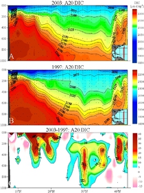
The A20 hydrographic survey consisting of LADCP/CTD/rosette sections and float deployments in the western North Atlantic was carried out September to October 2003 nominally along 55°W. The R/V Knorr departed Woods Hole, Massachusetts on 22 September 2003. A total of 88 LADCP/CTD/Rosette stations were occupied, and 5 profiling ARGO floats were deployed from 24 September - 18 October. Water samples (up to 36 depths), LADCP and CTD data were collected in most cases to within 10 meters of the bottom. The cruise ended in Port of Spain, Trinidad on 20 October 2003.
Carbon Data
CTD and other hydrographic data
WOCE section designation: A20_2003a
Chief Scientists: Dr. John Toole and Dr. Alison MacDonald
Dates: 22 September 2003 - 20 October 2003
Ship: R/V Knorr
Ports of call: Woods Hole, Ma. - Port of Spain, Trinidad
Number of stations: 88
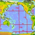
Geographic boundaries: 43°14.98'N to 6°58.63'N by 61°38.8'W to 50°36.97'W


