National Oceanic and
Atmospheric Administration
United States Department of Commerce

EcoFOCI

New Story Map Highlights the Importance of NOAA Long-term Observations in the Bering Sea

The Pivotal Recovery Story Map (ESRI) recounts the events in 2021 of how NOAA scientists raced against nature to save their most valuable scientific instruments in the Bering Sea. This interactive online map highlights the recovery efforts, the unique data collected and the implications it has for management. 

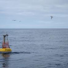
Yellow circular buoy with black words "Peggy" with a tower on top sitting in ocean with sea gulls flying above

Peggy is a biophysical mooring nicknamed after Peggy Dyson being deployed in the Bering Sea. The biophysical mooring site 2 (M2) is one of the longest running time series of its kind providing near-continuous measurements since 1995 in the southeastern Bering Sea.

Pages

Subscribe to RSS - EcoFOCI