P18-2017
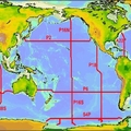
A hydrographic survey was conducted in the southern Pacific Ocean aboard the NOAA Ship Ronald H Brown from 19 Nov 2016 - 03 Feb 2017. A total of 211 rosette/CTD/LADCP stations were occupied on a transect running roughly along latitude 110°W and 103°W. CTD casts extended to within 10 meters of the seafloor and up to 24 water samples were collected throughout the water column. 29 floats, 20 drifters, and 2 SOCCOM float calibration stations were included.
Carbon Data
CTD and other hydrographic data
Section designation: P18
Leg 1:
Chief Scientists: Brendan Carter and Annie Bourbonnais
Dates: 2016 NOV 19 to 2016 DEC 24
Ship: R/V Ronald H Brown
Ports of call: San Diego, Ca to Hanga Roa, Easter Island, Chile
Number of stations: 115
Leg 2:
Chief Scientists: Rolf Sonnerup and Sarah Purkey
Dates: 2016 DEC 30 to 2017 FEB 03
Ship: R/V Ronald H Brown
Ports of call: Hanga Roa, Easter Island, Chile to Punta Arenas, Chile
Number of stations: 96
Geographic boundaries: 70° 0' 4.3" S to 22° 52' 10.5"N by 110°W to 95°W


