P06W 2017
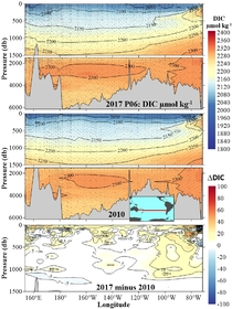
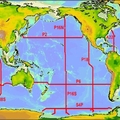
The Pacific Ocean P06W repeat hydrography line took place on board the RVIB Nathaniel B. Palmer from July 3, 2017 to August 17, 2017. The survey of P06W consisted of CTDO, rosette, LADCP, chipod, water samples and underway measurements. The ship departed from the port of Sydney, Australia and completed the cruise in the port of Papeete on the island of Tahiti, French Polynesia. A total of 143 stations (plus one test station) were occupied with one CTDO/rosette/LADCP/chipod package. At these stations, a total of 150 CTDO/rosette/LADCP/chipod casts, including 2 test casts were performed. The stations were, for the most part, a reoccupation of P06W-2009, and they are detailed in the following sections. 4 UW Argo floats, 2 SOCCOM floats, 5 SIO floats, 14 drifters, 2 SOLO II, and 3 Deep Solo floats were deployed on P06W. CTDO data and water samples were collected on each CTDO, rosette, LADCP, and chipod cast, usually within 10 meters of the bottom. Water samples were measured on board for salinity, dissolved oxygen, nutrients, DIC, pH, total alkalinity and CFCs/SF6. Additional water samples were collected and stored for shore analyses of Nitrate 𝛿15N and 𝛿18O, DOC/TDN, 13C/14C, POC, HPLC, DOP and DON.
Carbon Data
CTD and other hydrographic data
Section designation: P06W
Chief Scientists: Sabine Mecking and Isabella Rosso
Dates: 03 July 2017 to 17 August 2017
Ship: RVIB Nathaniel B. Palmer
Ports of call: Brisbane, Australia to Papeete, Tahiti
Stations: 143
Geographic boundaries 32° 30' S to 30° 4' S by 153° 28' E to 148° 54' W


