A16S-2014
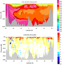
CLIVAR/GO-SHIP cruise A16S_2014 in the North Atlantic on NOAA ship Ronald H. Brown was successfully completed from Recife, Brazil to Punta Arenas, Chile. The A16S section ran due south along 25°W from approximately 6°S to 35°S, and then transited in a Southwest direction to South Georgia Island at 54°S, 36°W. The last part of the section crossed the Scotia Sea with a terminus at 60°S, 31°W. This is a repeat of the section previously occupied by the U.S. in 1989 and 2005. A total of 113 full water column CTD/O2/LADCP/rosette casts were completed along the A16S section at 30 nautical mile (nm) (54 km) spacing, with closer spacing at the basin boundaries near South Georgia. In addition, 14 Argo floats were deployed.
Carbon Data
CTD and other hydrographic data
Section designation: A16N
Chief Scientists: Dr. Rik Wanninkhof and Dr. Leticia Barbero
Dates: December 23, 2013 to February 4, 2014
Ship: R/V Ronald H Brown
Ports of call: Recife, Brazil - Punta Arenas, Chile
Number of stations: 113
Geographic boundaries: 6°S to 60°S by 36.4°W to 25°W


