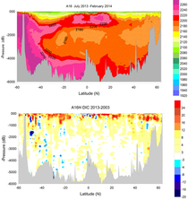
A16N-2013
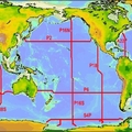
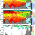
CLIVAR/GO-SHIP cruise A16S_2014 in the South Atlantic on NOAA ship Ronald H. Brown was successfully completed over two legs: Leg 1: (3 August to 23 August 2013) and Leg 2:(1 September to 3 October 2013). Leg 1 of the A16N_2013 cruise began in Reykjavik, Iceland and ended in Funchal, Portugal. Leg 2 of the A16N_2013 cruise began in Funchal, Portugal and ended in Natal, Brazil. The A16N_2013 cruise ran from approximately 66°N to 6°S, repeating the section previously occupied by the US in 1988 and 2003. A total of 145 full water column CTD/02/LADCP/rosette casts were completed along the A16N_2013 section at ~30 nautical mile (nm) spacing, with closer spacing near boundaries and between 3°N and 3°S. A 24 position rosette was used for the hydrocasts. Separate casts for trace metal analysis were occupied at approximately 60 nm spacing, using a specially designed 12 position trace metal clean winch and rosette system. In addition, 16 Argo floats and 10 surface drifters were deployed.
Carbon Data
CTD and other hydrographic data
Section designation: A16N
Chief Scientists, Leg 1: Dr. Molly Baringer and Dr. Denis L. Volkov
Chief Scientists, Leg 2: Dr. John Bullister and Dr. Rolf E. Sonnerup
Dates: 2013 August 01 to 2013 September 25
Ship: R/V Ronald H Brown
Ports of call: Reykjavik, Iceland - Funchal, Madeira, Portugal - Natal, Brazil
Number of stations: 145
Geographic boundaries: 6°S to 63.12°N by 29°W to 20°W


