Scientists Using Drones to Measure Black Carbon in the Climate-Sensitive Arctic Environment
April 22, 2015
Atmospheric chemists Trish Quinn at NOAA’s Pacific Marine Environmental Laboratory (PMEL) and Tim Bates of University of Washington’s Joint Institute for the Study of Atmosphere and Ocean (JISAO) are teaming up with other NOAA, U.S., and international colleagues to investigate the potential role of black carbon and other factors in driving climate change in the Arctic.
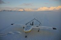
In order to make these fine-scale measurements in the harsh and remote Arctic environment, the researchers use Manta, an unmanned aerial system that looks like a small airplane with special sensors on board for capturing particles in the air. Black carbon, or soot, is produced in the burning of fossil fuels, biofuels and biomass, and may be produced by natural sources (volcanoes, forest fires) in addition to man-made activities. Watch the YouTube video created by NOAA Ocean Today which explains more about the sources and consequences of black carbon in our air.
Tiny black carbon containing particulates, smaller than 1 micron in diameter, can be transported throughout the atmosphere to remote regions far from the initial source. Black carbon emissions are the second strongest contributor to current global warming, after carbon dioxide and can affect the heat content of the atmosphere directly and indirectly. These dark particles act by absorbing sunlight, influencing cloud cover, and reducing the reflectivity of ice and snow cover.
“By examining the black carbon present in the clouds and atmosphere all the way to the snowpack, we are collecting ground-truthing data that will allow us to validate the modeled impact of black carbon on Arctic climate” said Quinn.
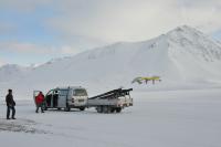
In April 2011, the NOAA/PMEL Atmospheric Chemistry Group, led by Bates and Quinn, went to Ny-Ålesund, Norway for the first time as a part of an international coordinated investigation of climate-cryosphere interactions study. Ny-Ålesund is a research station located on the island of Spitsbergen in Svalbard, Norway at 79°N. The researchers used Mantas for the first time, equipped with instruments on board to measure vertical distributions of particle light absorption, particle concentrations, and tracer elements able to identify sources of black carbon. Watch this YouTube video from the 2011 expedition to see more about how this technology works.
Quinn and Bates, accompanied by the PMEL engineering group, scientists from NOAA’s Earth System Research Laboratory/Chemical Sciences Division (ESRL/CSD), and Lamont-Doherty Earth Observatory are returning to Ny-Ålesund, Norway to continue and build upon the studies done in 2011. Partners from Norway, Italy, and Germany will bring instruments for intercomparison and additional measurements.
In April 2015, they are using new instruments to measure how soot particles affect light scattering and absorption in ice covered areas, to examine ice characteristics such as age and surface type, and measure the transfer of heat between the ice and the atmosphere. Among the instruments flying on the Manta are NOAA’s new miniaturized sensors developed at ESRL/CSD that will give a more complete picture of how soot and other atmospheric particles ultimately affect climate, by characterizing how atmospheric particles scatter light and quantifying the particle concentrations and size distributions.
The scientists will also be sampling snow (to measure light-absorbing particles, black carbon, and other elements that are deposited on the snow. Combining the data from the Manta instruments and snow measurements, scientists will be able to quantify how much black carbon is transported and deposited in the Arctic.
These measurements will help scientists understand how black carbon is driving climate change, and what effect reducing our input of black carbon to the atmosphere could have to reduce the impact of climate change in the future.
This work was funded by National Oceanic and Atmospheric Administration Unmanned Aerial System Program and the Gordon and Betty Moore Foundation and through cooperation with NOAA/Earth System Research Laboratory/Chemical Sciences Division, the Lamont-Doherty Earth Observatory, and the Norwegian Northern Research Institute (NORUT).
For more information about this story, please contact Lucia Upchurch at NOAA/PMEL at 206-526-6810 or lucia.upchurch@noaa.gov.
Banner image: The Manta unmanned aerial system being launched in Ny-Ålesund, on the island of Spitsbergen, Norway. Photo Credit: Kjell Sture Johansen/NORUT

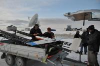
The Mantas have completed 9 flights so far this field season, totaling 10 hours of flying and measurement time. Photo Credit: Tom Grydeland/NORUT.


